User:MartinD
Jump to navigation
Jump to search
I'm MartinD, full name Martin van Dalen, mainly active on the Dutch Wikipedia.
I intend to use the Commons primarily for self-made pictures of Dutch items. So far:
The Netherlands
[edit]Hiking-related (scenes along Dutch hiking routes)
[edit](Images may also be suitable for other purposes)
-
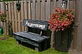
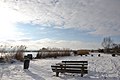
 Paalkampeerterrein bij Leersum (opgeheven)/Basic camping site near Leersum (now defunct)
 -
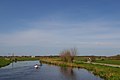
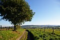
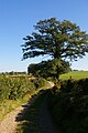
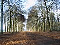 On the Utrechtpad hiking trail, south of Leersum
 -
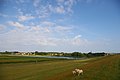
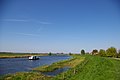
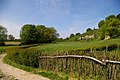
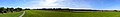
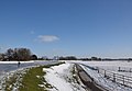
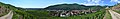
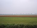 Flower bulb fields between Zeewolde and Almere, along the Pionierspad hiking trail
 -
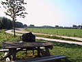
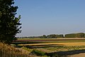
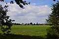
 West of Oudewater, on the Floris V hiking trail
 -
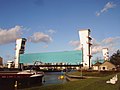
 "Plofsluis" near Nieuwegein, the Netherlands, part of (former) Dutch defence works
 -
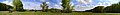
 Fort Honswijk, on the river Lek near Culemborg, the Netherlands
 -
 Small fortress near Leerdam, the Netherlands, to defend weak spot in inundation system
 -
 Sherman tank encased in concrete, near Olst, the Netherlands
 -
 Scene on the Zuiderzeepad hiking route, east of Nijkerk, the Netherlands
 -
 Tolhuissluis lock, south-southeast of Amsterdam
 -
 On the Veluwe Zwerfpad hiking trail, in the Hoge Veluwe national park, north of Arnhem
 -
 On the Zevenwoudenpad hiking trail
 -
 Zuiderzeepad Hiking trail near Vollenhove, Overijssel
 -
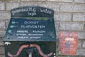
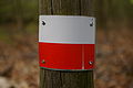 Standard route markings on Dutch long distance hiking routes
 -
 Sign indication change of direction of hiking route
 -
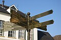
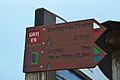
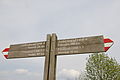 Direction sign on crossing long distance hiking routes
 -
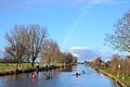
 Pelgrimspad hiking route between Tolhuissluis lock and Vrouwenakker
 -
 View of De Mok, Texel
 -
 Dunes near Den Hoorn, Texel
 -
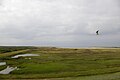 View of De Slufter, Texel
 -
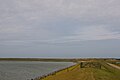
 View of De Schorren, Texel
 -
 The lighthouse on the northern end of Texel
 -
 View of De Cocksdorp, Texel
 -
 View of Oost, Texel
 -
 View of Den Burg, Texel
 -
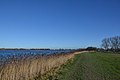
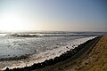 Oosterschelde estuary near Viane, Zierikzee
 -
 Signpost of the Scholtenpad hiking trail in Winterswijk
 -
 "Green Border" between the Netherlands and Germany
 -
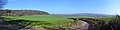
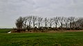
 Landscape on the Scholtenpad
 -
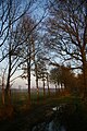 Early morning on the Scholtenpad
 -
 Farm campsite near Meddo
 -
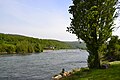
 River Eem near Eembrugge
 -
 Oosterschelde near Stavenisse
 -
 On the Oosterscheldepad hiking trail near Sint Annaland
 -
 Oosterschelde near Stavenissepolder
 -
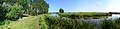
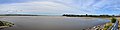
 Panoramic of Oosterschelde near Sint Maartensdijk
 -
 On the Groene Hartpad hiking trail, alongside the river Meije
 -
 On the Marskramerpad hiking train, north of Woerdense Verlaat
 -
 Scheenesluis, on the Zuiderzeepad hiking trail
 -
 Hamlet of De Donk, mun. Graafstroom, prov. South Holland
 -
 On the Pelgrimspad hiking trail near De Donk
 -
 On the Pelgrimspad hiking trail near Bleskensgraaf
 -
 On the Pelgrimspad hiking trails along the river Vlist
 -
 De Avelingen natural landscape, west of Gorinchem
 -
 A very kind service to hikers at Hardinxveld-Giessendam
 -
 Krijtlandpad near Epen
 -
 Krijtlandpad near Noorbeek
 -
 Krijtlandpad near Slenaken
 -
 Sint Odiliënberg from the Pieterpad hiking route
 -
 On the Pieterpad at Windraak: water purported as a cure for several illnesses
 -
 On the Pieterpad near Bemelen
 -
 On the Maarten van Rossumpad near Heelsum
 -
 On the Veluwe Zwerpad near the Posbank, Rheden
 -
 On the Maarten van Rossumpad hiking route, at Zoelmond
 -
 On the Maarten van Rossumpad hiking route near Lienden
 -
 On the Pelgrimspad hiking route at Bilderdam
 -
 On the Pelgrimspad hiking route at Aalsmeer, Geijlwijckerweg
 -
 On the Zuiderzeepad hiking route, just south of Stavoren
 -
 Basic camping site between Groot-Ammers and Bleskensgraaf (now defunct)
 -
 Basic campsite near Zoeterwoude near Leiden (now defunct)
 -
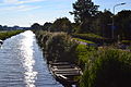
 On the Groene Hartpad hiking trail between Alphen aan den Rijn and Aarlanderveen
 -
 On the Groene Hartpad hiking trail at Zoetermeer: view of The Hague
 -
 On the Graafschapspad hiking trail near Olburgen
 -
 On the Maarten van Rossumpad hiking route: view of the Grebbeberg
 -
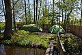
 Campsite run by the National Forerstry Service at Groesbeek, near Nijmegen
 -
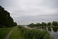
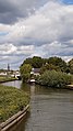
 View of the Vollenhover Kanaal, on the Zuiderzeepad hiking route
 -
 Work of art near the Vollenhover Kanaal
 -
 On the Waterliniepad hiking route near Culemborg
 -
 On the Maarten van Rossumpad, view of Arnhem
 -
 Pelgrimspad hiking route near Papenveer
 -
 Pelgrimspad hiking route just south of Aarlanderveen
 -
 Pelgrimspad hiking route north of Zwammerdam
 -
 Dubbele Wiericke canal at Driebruggen, on the Pelgrimspad hiking route
 -
 Romeinse Limespad hiking route south of Bodegraven
 -
 Fort aan de Drecht, Uithoorn, on the Waterliniepad hiking route
 -
 On the Floris V-pad hiking route near Ankeveen
 -
 On the Floris V-pad hiking route near Ankeveen
 -
 On the Noaberpad hiking route at the Dutch-German border
 -
 On the Noaberpad hiking route near Enschede in the vicinity of the Dutch-German border
 -
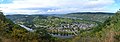
 View from the Overijssels Havezatenpad hiking route on the village of Beckum
 -
 On the Overijssels Havezatenpad hiking route, north of Haaksbergen
 -
 On the Marskramerpad hiking route at Breukelen railway station
 -
 On the Marskramerpad hiking route near Breukelen railway station: the windmill dating from ca. 1675
 -
 On the Romeinse Limespad hiking route in Bodegraven, on the bank of the Oude Rijn
 -
 On the Trekvogelpad hiking route: view from the Grebbeberg, near Rhenen
 -
 On the Marskramerpad hiking route on Groot Bylaer estate
 -
 On the Marskramerpad hiking route in Terschuur
 -
 On the Marskramerpad hiking route: view of Zwartebroek
 -
 On the Marskramerpad hiking route: sheep pen near Boeschoten
 -
 On the Groene Hartpad hiking route near Woerdense Verlaat
 -
 On the Waterliniepad hiking route: view of the Oostkolk in Spaarndam
 -
 On the Waterliniepad hiking route near Spaarndam, view towards the South
 -
 On the Waterliniepad hiking route south-west of Werkendam, on the edge of the Biesbosch National Park
 -
 On the Pelgrimspad hiking route: view of the Aarkanaal canal near Nieuwveen
 -
 On the Waterliniepad hiking route, Vuurlijn in Uithoorn
 -
 On the Waterliniepad hiking route between Uithoorn and Nes aan de Amstel
 -
 Damsluis (coupure) in De Kwakel, along the Waterliniepad hiking route
 -
 On the Marskramerpad hiking route along the Kromme Mijdrecht river
 -
 On the Waterliniepad hiking route along the Waver river
 -
 On the Waterliniepad hiking route near Botshol protected area
 -
 On the Grenslandpad hiking route just outside Thorn
 -
 On the Pelgrimspad hiking route: view of Thorn
 -
 On the Krijtlandpad hiking route near Epen
 -
 On the Krijtlandpad hiking route just north of Slenaken
 -
 On the Krijtlandpad hiking route:view of Vijlen
 -
 Krijtlandpad near the Drielandenpunt
 -
 On the Veluwe Zwerfpad hiking route near Elspeet
 -
 On the Veluwe Zwerfpad hiking route near Ermelo
 -
 On the Veluwe Zwerfpad hiking route on the Speulderveld
 -
 On the Veluwe Zwerfpad hiking route on the Kootwijkerzand
 -
 Junction of the Marskramerpad and the Veluwe Zwerfpad at Hoog Buurlo
 -
 On the Zuiderzeepad hiking route: Staverden castle
 -
 Romeinse Limespad and Waterliniepad near Bunnik
 -
 Betuwepad and Grote Rivierenpad near Beesd
 -
 Marskramerpad near Beekbergen
 -
 Marskramerpad near Wilp.jpg
 -
 Marskramerpad on estate De Poll
 -
 Veluwe Zwerfpad and Maarten van Rossumpad near Posbank
 -
 Hiking route marking of Waddenwandelen hiking route on Texel
 -
 Graafschapspad, bridge across Berkel river near Almen
 -
 Marina on the Lek river in Nieuwegein-Zuid, along the Waterliniepad
 -
 On the Pelgrimspad, on the ferry between Gorinchem and Woudrichem
 -
 On the Pelgrimspad, windmill Nooit Gedagt in Woudrichem
 -
 Op the Pelgrimspad, along the Afgedamde Maas near Woudrichem
 -
 On the Pelgrimspad on the dike of the Waal near Brakel


Other subjects
[edit]-
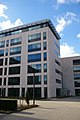
 "Infitity" office building, Amsterdam, formerly known as "ING House"
 -
 Prinses Irene sluizen/Princess Irene locks, near Wijk bij Duurstede
 -
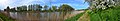
 Gelredome sports stadium and events hall, Arnhem
 -
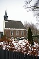
 Thamerkerk church, Uithoorn
 -
 Metro-streetcar ("sneltram") on line 51, Amstelveen
 -
 Drawbridge at Ouderkerk aan de Amstel
 -
 Blood donation
 -
 Museumtram in Amstelveen
 -
 Dutch lifeboat
 -
 Dealing room in an Amsterdam bank
 -
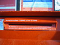 Dutch letterbox with reduced insertion slot to prevent insertion of fireworks
 -
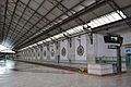
 Duivendrecht railway station, south of Amsterdam
 -
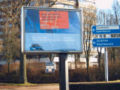 Just a random billboard, used purely as an illustration
 -
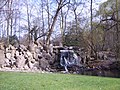 Artificial waterfall in Park Sonsbeek, Arnhem
 -
 View of Nes aan de Amstel, a village between Amstelveen and Uithoorn, south of Amsterdam
 -
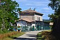
 Former railway station (now a café), Uithoorn, the Netherlands
 -
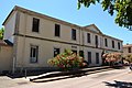
 Town hall, Uithoorn, the Netherlands
 -
 Kromme Mijdrecht, a river south-west of Amsterdam
 -
 River Amstel in autumn, just south of Uithoorn, the Netherlands
 -
 Nudist beach at Zandvoort, west of Amsterdam
 -
 Flood barrier in the Hollandse IJssel river at Krimpen aan de IJssel, near Rotterdam
 -
 Westeinder Plassen lakes, south of Aalsmeer, seen from the top of the Aalsmeer water tower
 -
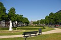
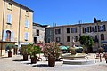
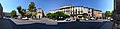
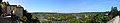
 Central square, Amstelveen
 -
 "Coupure" in Bovenkerkerweg, Amstelveen
 -
 "Coupure" in Bovenkerkerweg, Amstelveen (detail)
 -
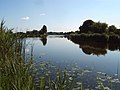
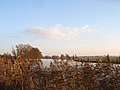
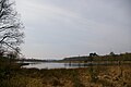
 National park Utrechtse Heuvelrug, Egelmeer
 -
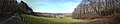
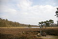
 National Park Utrechtse Heuvelrug, Leersumse veld
 -
 Jansbinnensingel, Arnhem
 -
 Blokzijl, Overijssel
 -
 Dike near Bemmel, Gelderland
 -
 Kalenberg, Overijssel
 -
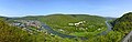
 View on Montferland Hills near Braamt, Achterhoek, Gelderland
 -
 View on the hamlet of Nederland, Overijssel
 -
 Dutch-German border near Netterden, Achterhoek, Gelderland
 -
 Railway tunnel in Betuweroute near Zevenaar
 -
 Speulderveld, near Speuld, Ermelo, Gelderland
 -
 Vollenhove, Overijssel
 -
 Roadworks on the bypass of N 201 highway at Aalsmeer
 -
 Waver river, south of Amsterdam
 -
 Amstel rivier near Nes, south of Amsterdam
 -
 Overview of Ronde Hoep polder, south of Amsterdam
 -
 Skaters on the river Amstel at Uithoorn
 -
 Mercedes G-class used by the Amsterdam-Amstelland police
 -
 Natuurkampeerterrein (campsite) De Dasselaar near Zeewolde
 -
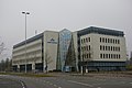
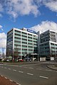
 Head office of KLM airlines, Amstelveen
 -
 Panoramic of the Philipsdam locks complex, Zeeland and South Holland
 -
 Postmodern architecture in Amsterdam, Lamonggracht, Java-eiland
 -
 In the Veluwezoom National Park
 -
 Retro-style architecture in Arnhem
 -
 Retro-style architecture in Uithoorn, the Netherlands
 -
 Retro-style architecture in Uithoorn, the Netherlands
 -
 Retro-style architecture in Maarssen, the Netherlands
 -
 Deserted check-in stations at Schiphol Airport on April 17, 2010
 -
 Laan van Deshima, Amstelveen
 -
 Uddelermeer, a small lake near Uddel, Gelderland
 -
 View on Ouderkerk aan de Amstel from the Amstel bridge
 -
 View of KNSM-eiland, new housing on site of former harbour in the east of Amsterdam
 -
 Former railway bridge across the Amstel at Uithoorn, now bus bridge
 -
 Groene Bedstee, a berceau in the west of Arnhem
 -
 Eerde Castle, near Ommen
 -
 Sculpture on the bank of the Regge river near Ommen
 -
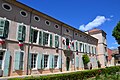
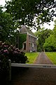 Historic house Soeslo, near Zwolle
 -
 Open drainage pipe to transport water from pumping station to river Amstel, south of Amstelveen
 -
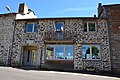
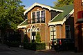 House in Uithoorn, listed as a monument (just to add to the collection of buildings in the Dutch national register of monuments on the Dutch Wikipedia, actually...)
 -
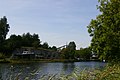
 View of Bilderdam
 -
 Kapsalon (or Patat kapsalon), a fusion-cooking Dutch snack
 -
 Farmhouse in de Kwakel, listed as a monument
 -
 Farmhouse in de Kwakel, listed as a monument
 -
 Fortress near Kudelstaart
 -
 Statue of Jan Jansz. Weltevree in De Rijp
 -
 Church of Stompetoren, Schermer
 -
 Church of Markenbinnen, mun. Graft-De Rijp
 -
 Markenbinnen, Dorpsstraat
 -
 Anti-tank obstacles near Muiden
 -
 KLM Cityhopper offices, Schiphol-Oost
 -
 KLM health servcies offices, Schiphol-Oost
 -
 Martinair and Transavia offices, Schiphol-Oost
 -
 Schiphol Group offices
 -
 Schiphol World Trade Center
 -
 Amsterdam Airlines office, Schiphol-Rijk
 -
 ArkeFly office, Schiphol-Rijk
 -
 Former Martinair office, Schiphol
 -
 Transavia office, Schiphol
 -
 Tents of the Occupy-movement in front of the Amsterdam Stock Exchange
 -
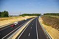 A 74 motorway south of Venlo
 -
 Rhine near Arnhem Meinerswijk
 -
 Casemate in the IJssellinie near Arnhem
 -
 Bus lane near De Kwakel
 -
 New route of N201 provincial road, north of Uithoorn
 -
 Ferry across the river Amstel at Nessersluis
 -
 Panoramic of Oldetrijne, Friesland
 -
 Planes parked at Schiphol Airport during the COVID-19 pandemic
 -
 Libellebos, a small wood in Uithoorn
 -
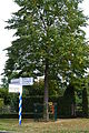
 Sign requesting people not to visit hiking path during the COVID-19 pandemic in the Netherlands
 -
 "Take-away" service in a Dutch public library during the COVID-19 pandemic
 -
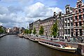 Laid up canal boats in Amsterdam during the COVID-19 pandemic
 -
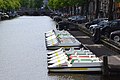 Laid up pedal boats in Amsterdam during the COVIC-19 pandemic
 -
 Social distance warning in City Plaza shopping centre, Nieuwegein, during the COVID-19 pandemic
 -
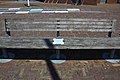 Sign on bench in Bodegraven interdicting eating or drinking during the COVID-19 pandemic
 -
 Blauwe Kamer natural monument closed due to COVID-19 pandemic
 -
 Dutch courtroom during COVID-19 pandemic
 -
 Sanitizing equipment in Dutch supermarket during COVID-19 pandemic
 -
 Social distance indicators at Breukelen station during COVID-19 pandemic
 -
 Fort bij het Steurgat (former) fortress seen from the West, showing how it has been converted into housing
 -
 Skating on the Amstel river in Uithoorn: a very rare event
 -
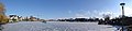 Amstel river in Uithoorn frozen over
 -
 Skaters on the Zijdelmeer lake, Uithoorn: a fairly rare event
 -
 New ferry across the Amstel river at Nessersluis
 -
 Uithoorn bus station panoramic
 -
 Detail of pantograph of VDL Citea electric bus at charging station
 -
 Merwestein halt, Nieuwegein.jpg
 -
 Vossedal rest area, just south of Beek-Elsloo on the A2 motorway
 -
 Works on the embankment of the Amsteltram line where it will cross the N201 road in Amstelveen
 -
 Rails being laid near the terminal of the Amsteltram tram line near the former railway station in Uithoorn
 -
 Rails being laid for the Amsteltram at Uithoorn bus station
 -
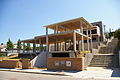
 Exterior of Uithoorn public library
 -
 Progress in construction of viaduct for Amsteltram tram line across N201 road
 -
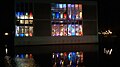
 Interior of Uithoorn public library
 -
 Panoramic view of Oudeschild, on the island of Texel
 -
 De Hoeksteen, Uithoorn: former church, later restaurant
 -
 Rails being laid for the Amsteltram near Aan de Zoom, Uithoorn
 -
 Bridge across Amstel river at De Kwakel/Vrouwenakker
 -
 Dorpsstraat, Vreeswijk, Nieuwegein
 -
 Courthouse in Utrecht
 -
 Price list of the Jan Coevertveer ferry, Ouderkerk aan de Amstel
 -
 Intersection of Oude Rijn with Aarkanaal and Gouwe in Alphen aan den Rijn
 -
 Aarkanaal north of Zegerbrug, bear Alphen aan den Rijn
 -
 Upper level of NS VIRM train set during COVID-19 crisis during rush hour between Amsterdam and Utrecht


Public library statistics
[edit]-
 Number of books lent
 -
 Number of visiors
 -
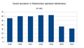
 E-books lent
 -
_collection_of_e-books_2015-2021.png/120px-Dutch_libraries_(central)_collection_of_e-books_2015-2021.png) (Central) collection of e-books
(Central) collection of e-books


_collection_of_e-books_2015-2021.png)
France
[edit]-
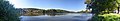
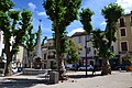
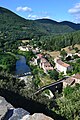
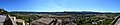
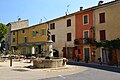
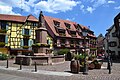
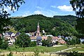
 Overview of Lagrasse, Dept. Aude, near Carcassonne, France
 -
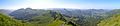
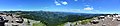
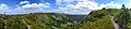
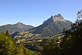
 View on Puy Griou (and Puy Mary), Monts du Cantal, France
 -
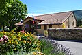
 Village of Calviac, Dept. Lot, near St. Céré, France
 -
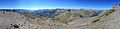
 View on Puy Mary (and Puy de la Tourte) from Col de Serre, Monts du Cantal, France
 -
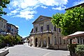
 Narbonne (France), Canal de la Robine from Boulevard Gambetta
 -
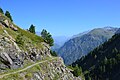
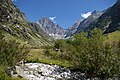 Olan peak (3564 m) in Ecrins national park, France
 -
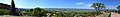
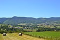
 Panoramic view of the Aude valley, east of Carcassonne, France, looking south
 -
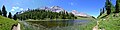
 View of the Refuge de Vallonpierre in the Écrins National park, looking north
 -
 View of Corps, dept. Isère
 -
 Minerve, Hérault
 -
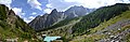
 In the Valgaudemar, Écrins National park, France
 -
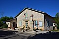
_Mairie.jpg/120px-Greffeil_(Aude)_Mairie.jpg) Town hall of Greffeil, Dept. Aude, France
Town hall of Greffeil, Dept. Aude, France -
 Landscape in the Ariège
 -
 Ariège river at Tarascon-sur-Ariège
 -
 Auzat, dept. Ariège, centre
 -
 Cahuzac-sur-Vère, dept. Tarn, centre
 -
 Creissels, dept. Aveyron
 -
 Gèdre, dept. dept. Hautes-Pyrénées, centre
 -
 On the GR 10 hiking route, near Auzat, dept. Ariège
 -
 Hamlet of Suc-et-Sentenac, near Vicdessos dept. Ariège
 -
 View of Ambialet, dept. Tarn
 -
 Chagny, dept. Saône-et-Loire, Place d'Armes
 -
 Chenôves, dept. Saône-et-Loire
 -
 Villar-d'Arene, dept. Hautes-Alpes
 -
 La Grave, dept. Hautes-Alpes, view on La Meije mountain range
 -
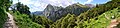
 On the GR 54 hiking trail near Le Chazelet, NW of La Grave
 -
 View of Puimoisson, dept. Alpes-de-Haute-Provence
 -
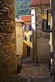 Prats-de-Mollo-la-Preste, dept. Pyrénées-Orientales, Rue des Remparts
 -
 View of Montferrer, dept. Pyrénées-Orientales
 -
 On the GR 10 hiking route near the Col de la Cirere, dept. Pyrénées-Orientales
 -
 View of Le Tech, dept. Pyrénées-Orientales
 -
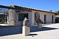
 Town hall of Boule-d'Amont, dept. Pyrénées-Orientales
 -
 Ladern-sur-Lauquet, dept. Aude
 -
 Leuc, dept. Aude
 -
 Station of La Rochelle-Ville, mural in booking hall
 -
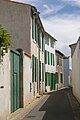 Sainte-Marie-de-Ré, dept. Charente-Maritime
 -
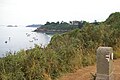 On the E9 European hiking trail near Cancale, dept. Ille-et-Villaine
 -
 On the E9 European hiking trail near Cap Blanc-Nez
 -
 On the top of the Puy Mary on the GR 4 hiking route
 -
 On the GR 4 hiking route near Breche de Rolland, view on Puy Griou
 -
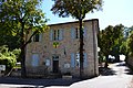
 Town hall of Clermont-sur-Lauquet, dept. Aude
 -
_town_hall.JPG/120px-Aveze_(Gard)_town_hall.JPG) Town hall of Avèze, dept. Gard
Town hall of Avèze, dept. Gard -
 Town hall of Crayssac, dept. Lot
 -
 Town hall of Ladern-sur-Lauquet, dept. Aude
 -
_town_hall.JPG/120px-St_Hilaire_(Aude)_town_hall.JPG) Town hall of Saint-Hilaire, dept. Aude
Town hall of Saint-Hilaire, dept. Aude -
 Town hall of Mas-Cabardès, dept. Aude
 -
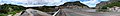
 Panoramic view of the Col d'Allos (from the pass to the north)
 -
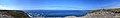
 Panoramic view from the Col de la Bonette towards the north
 -
 Panoramic view from the Col de la Bonette towards the south
 -
 Dordogne river at Lalinde
 -
 Automat for meat and charcuterie in Cahors
 -
 Tents on the beach of Dinard
 -
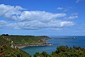
 On the E9 European hiking route just East of Cap Fréhel, Brittany
 -
 E9 European hiking route just West of Dinard, Brittany
 -
 E9 European hiking route at Pointe de Brézellec, Brittany
 -
 E9 European hiking route just west of the semaphore at Pointe du Raz, Brittany
 -
 E9 European hiking route just south of the semaphone at Pointe du Raz, Brittany
 -
 GR10 hiking route just west of Lescun
 -
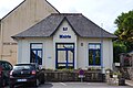
 Town hall of Kerlouan, Finistère
 -
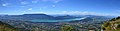
 Town hall of Lagrasse, dept. Aude
 -
 Library of Lampaul-Guimiliau, Finistère
 -
 Town hall of Lampaul-Guimiliau, Finistère
 -
 Panoramic from Landévennec, Finistère
 -
 Pub and library in Landévennec, Finistère
 -
 Town hall of Landévennec, Finistère
 -
 Landscape south of La Berarde, Isère
 -
 View from de Refuge du Chatelleret, north of La Berarde, Isère
 -
 Panoramic of the Baie de Somme and Le Crotoy
 -
 Quay de Léon, Morlaix, Finistère
 -
 Center of Plorec-sur-Arguenon, Côtes-d'Armor
 -
 Town hall of Plorec-sur-Arguenon, Côtes-d'Armor
 -
 Land yachts on the beach of Plounéour-Trez, Finistère
 -
 Fishing vessels in the harbour of Roscoff, Finistère
 -
 View from Saint-Valery-sur-Somme
 -
 Town hall of Verzeille, dept. Aude
 -
 Yarn bombing in Quimper, July 2018
 -
_town_hall.jpg/120px-Brixey-aux-Chanoines_(Meuse)_town_hall.jpg) Town hall of Brixey-aux-Chanoines, dept. Vosges
Town hall of Brixey-aux-Chanoines, dept. Vosges -
 Confluence of Rhône and Saône at Lyon
 -
_town_hall.jpg/120px-Domremy-la-Pucelle_(Vosges)_town_hall.jpg) Town hall of Domrémy-la-Pucelle, dept. Vosges
Town hall of Domrémy-la-Pucelle, dept. Vosges -
_town_hall.jpg/120px-Greux_(Vosges)_town_hall.jpg) Town hall of Greux, dept. Vosges
Town hall of Greux, dept. Vosges -
_center.jpg/120px-La_Chapelle-en-Vercors_(Drome)_center.jpg) Centre of La Chapelle-en-Vercors, dept. Drôme
Centre of La Chapelle-en-Vercors, dept. Drôme -
_town_hall.jpg/120px-La_Chapelle-en-Vercors_(Drome)_town_hall.jpg) Town hall of La Chapelle-en-Vercors, dept. Drôme
Town hall of La Chapelle-en-Vercors, dept. Drôme -
.jpg/120px-Landscape_near_Domremy-la-Pucelle_(Vosges).jpg) Landscape near Domrémy-la-Pucelle, dept. Vosges
Landscape near Domrémy-la-Pucelle, dept. Vosges -
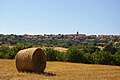
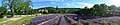
.jpg/120px-Lavender_fields_south_of_Sault_(Vaucluse).jpg) Lavender fields south of Sault, dept. Vaucluse
Lavender fields south of Sault, dept. Vaucluse -
_town_hall.jpg/120px-Les_Houches_(Haute-Savoie)_town_hall.jpg) Town hall of Les Houches, dept. Haute-Savoie
Town hall of Les Houches, dept. Haute-Savoie -
 North entrance of Lyon-Perrache railway station
 -
 South entrance of Lyon-Perrache railway station
 -
_former_railway_station.jpg/120px-Maxey-sur-Meuse_(Vosges)_former_railway_station.jpg) Maxey-sur-Meuse, Vosges, former railway station
Maxey-sur-Meuse, Vosges, former railway station -
_town_hall.jpg/120px-Maxey-sur-Meuse_(Vosges)_town_hall.jpg) Town hall of Maxey-sur-Meuse, dept. Vosges
Town hall of Maxey-sur-Meuse, dept. Vosges -
.jpg/120px-Meuse_at_Domremy-la-Pucelle_(Vosges).jpg) The Meuse at Domrémy-la-Pucelle, dept. Vosges
The Meuse at Domrémy-la-Pucelle, dept. Vosges -
.jpg/120px-Old_sign_in_Saint_Saturnin-les-Apt_(Vaucluse).jpg) Old traffic sign in Saint Saturnin-les-Apt, dept. Vaucluse
Old traffic sign in Saint Saturnin-les-Apt, dept. Vaucluse -
.jpg/120px-View_from_Aurel_(Vaucluse).jpg) Landscape near Aurel, dept. Vaucluse
Landscape near Aurel, dept. Vaucluse -
.jpg/120px-View_from_Reilhanette_(Drome).jpg) View from Reilhanette, dept. Drôme
View from Reilhanette, dept. Drôme -
.jpg/120px-View_from_Sault_(Vaucluse).jpg) View from Sault, dept. Vaucluse
View from Sault, dept. Vaucluse -
.jpg/120px-View_of_Greux_(Vosges).jpg) View of Greux, dept. Vosges
View of Greux, dept. Vosges -
 Town hall of Chaudeyrolles, dept. Haute-Loire
 -
 Landscape near Chaudeyrolles, dept. Haute-Loire
 -
 On the GR5 hiking route at Lac Miroir, above Ceillac, dept. Hautes-Alpes
 -
 On the GR5 hiking route at Lac Sainte Anne, above Ceillac, dept. Hautes-Alpes
 -
 Early morning on the GR5 hiking route north of Arvieux, dept. Hautes-Alpes
 -
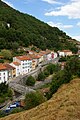
 Centre of Le Cheylard, dept. Ardèche
 -
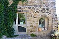
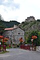
 View of Banne, dept. Ardèche, from castle ruins
 -
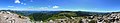 View from Mont Gerbier de Jonc towards the South
 -
 View from Mont Gerbier de Jonc towards the North
 -
 View from the church of Lablachère, dept. Ardèche
 -
 Town hall of Grignan, dept. Drôme
 -
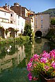
 Public wash house (18th century), Place du Mail, Grignan, dept. Drôme
 -
 Town hall of Chamaret, dept. Drôme
 -
 Former railway station of Dieulefit, dept. Drôme
 -
 Town hall of Vesc, dept. Drôme
 -
 Town hall of Montjoux, dept. Drôme
 -
 Place de la Canourge, Saint-Hippolyte-du-Fort, dept. Gard
 -
 Town hall of Saint-Hippolyte-du-Fort, dept. Gard
 -
 Former train station of Sauve, dept. Gard
 -
 Place Florian, Sauve, dept. Gard
 -
 View on the southern part of Sauve, dept. Gard
 -
 Place du Docteur Jean Astruc, Sauve, dept. Gard
 -
 Town hall of Durfort-et-Saint-Martin-de-Sossenac, dept. Gard
 -
 Landscape south of Durfort-et-Saint-Martin-de-Sossenac, Gard, France, on the GR63 hiking trail
 -
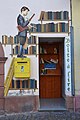
 Trompe-l'œil in Bedarieux, dept. Hérault
 -
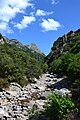 The Gorges d'Héric north of Mons, dept. Hérault
 -
_tourist_office.jpg/120px-Mons_(Hérault)_tourist_office.jpg) Tourist Office in Mons, dept. Hérault
Tourist Office in Mons, dept. Hérault -
 Faubourg Saint-Roch, Olargues, dept. Hérault
 -
 Olargues, dept. Hérault, seen from the Pont de Diable
 -
 Town hall of Saint-Chinian, dept. Hérault
 -
 Trompe-l'œil in Saint-Chinian, dept. Hérault
 -
 Unusual hiking route marker in Saint-Gervais-sur-Mare, dept. Hérault
 -
 Centre of Saint-Gervais-sur-Mare, dept. Hérault
 -
 Lavender fields in Le Poët-Laval, dept. Drôme
 -
 Landscape near La Bégude-de-Mazenc, dept. Drôme
 -
 Landscape near Grignan, dept. Drôme
 -
 Landscape near Chamaret, dept. Drôme
 -
 Town hall of La Garde-Adhémar, dept. Drôme
 -
 Landscape near La Garde-Adhémar, dept. Drôme
 -
 Landscape near Vesc, dept. Drôme
 -
 Landscape near Montjoux,dept. Drôme
 -
 View of Alès, dept. Gard
 -
 View of Anduze, dept. Gard
 -
 Town hall of Vallouise-Pelvoux, dept. Hautes-Alpes
 -
 Landscape west of Ailefroide, dept. Hautes-Alpes, Frankrijk.
 -
 View from the Glacier Blanc towards Vallouise-Pelvoux, dept. Hautes-Alpes
 -
 Lac de la Douche on the GR54 hiking route
 -
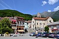 Saint-Firmin, dept. Hautes-Alpes
 -
 Cascade du Buchardet, south of La Chapelle-en-Valgaudemar, dept. Hautes-Alpes
 -
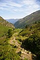
 View towards the North from l'Aup, south of La Chapelle-en-Valgaudemar, dept. Hautes-Alpes
 -
 View towards the South from l'Aup, south of La Chapelle-en-Valgaudemar, dept. Hautes-Alpes
 -
 Church of Saint-Maurice-en-Valgodemard, dept. Hautes-Alpes
 -
 Town hall of Saint-Maurice-en-Valgodemard, dept. Hautes-Alpes
 -
 View of the Lac du Sautet from Corps, dept. Isère
 -
 On the GR4 hiking route at the Gorges du Chassezac, dept. Ardèche
 -
 Town hall of Simiane-la-Rotonde, dept. Alpes-de-Haute-Provence
 -
 On the GR4 hiking route near Simiane-la-Rotonde, dept. Alpes-de-Haute-Provence
 -
 Landscape near Simiane-la-Rotonde, dept. Alpes-de-Haute-Provence
 -
 On the GR50 hiking route near the Col d'Hurtières, dept. Isère
 -
 On the GR50 hiking route near the sanctuary of La Salette, dept. Isère
 -
 Town hall of Viens, dept. Vaucluse
 -
 On the GR6 hiking route at Oppedette, dept. Alpes-de-Haute-Provence
 -
 Town hall of Oppedette, dept. Alpes-de-Haute-Provence
 -
 Library of Revest-des-Brousses, dept. Alpes-de-Haute-Provence
 -
 Town hall of Revest-des-Brousses, dept. Alpes-de-Haute-Provence
 -
 Place de la Fontaine, Saint-Michel-l'Observatoire, dept. Alpes-de-Haute-Provence
 -
 View on Saint-Michel-l'Observatoire, dept. Alpes-de-Haute-Provence
 -
 Library of Apt, dept. Vaucluse
 -
 Landscape near Viens, dept. Vaucluse
 -
 Trompe-l'oeil in Le Puy-en-Velay, corner of Rue Droite en Rue du Faubourg Saint-Jean
 -
 Detail of trompe-l'oeil in Le Puy-en-Velay, corner of Rue Droite and Rue du Faubourg Saint-Jean
 -
 Le Puy-en-Velay railway station
 -
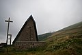
 Church of Saint-Arcons-de-Barges, dept. Haute-Loire
 -
 Town hall of Saint-Arcons-de-Barges, dept. Haute-Loire
 -
 View of Barges, dept. Haute-Loire
 -
 Town hall of Arlempdes, dept. Haute-Loire
 -
 Goudet and the Chateau de Beaufort seen from the GR70 hiking route, dept. Haute-Loire
 -
 Hikers and donkey on the GR70 hiking route in Goudet, dept. Haute-Loire
 -
 On the GR70 hiking route west of Le Monastier-sur-Gazeille, dept. Haute-Loire
 -
 Nancy railway station, west entrance
 -
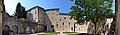 Couvent des Cordeliers, Forcalquier, dept. Alpes-de-Haute-Provence
 -
 Place du Bourguet, Forcalquier, dept. Alpes-de-Haute-Provence
 -
 Place Gabriel Péri, Apt, dept. Vaucluse
 -
 View from Roussillon, dept. Vaucluse
 -
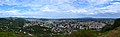
 View of Le Puy-en-Velay towards the south-west
 -
 View of Le Puy-en-Velay towards the north
 -
 Abbey of Le Monastier-sur-Gazeille, dept. Haute-Loire
 -
 Moselle at Liverdun, dept. Meurthe-et-Moselle
 -
 Moselle seen from the Rue Porte Haute, Liverdun, dept. Meurthe-et-Moselle
 -
 Nancy railway station forecourt
 -
 Place Stanislas, Nancy
 -
 Aire de l'Arclusaz rest area on the A43 motorway, Savoie
 -
_town_hall.jpg/120px-École_(Savoie)_town_hall.jpg) Town hall of École, dept. Savoie
Town hall of École, dept. Savoie -
 On the GR4 hiking route near the Puy de Sancy
 -
 On the GR5 hiking route neat Ribeauvillé, dept Haut-Rhin
 -
 Different route markings on the GR5 at the Ballon d'Alsace
 -
 On the GR5 hiking route near Lac Blanc
 -
 On the GRP Tour du Lac d'Annecy at the Jardins d'Europe in Annecy
 -
 La Motte-en-Bauges, dept. Savoie
 -
 In the Massif des Bauges, dept. Savoie, on the trail from the Col de l'Arclusaz
 -
 Town hall of Orcival, dept. Puy-de-Dôme
 -
 View from the Col de l'Arclusaz, dept. Savoie, towards the north
 -
 View of the Isère from the Col de l'Arclusaz, dept. Savoie
 -
 View from Crêt de Châtillon (summit of mt. Sermoz), dept. Savoie
 -
 View of Mont Blanc from Crêt de Châtillon, dept. Savoie
 -
 Panoramic from Col d'Orgeval (dept. Savoie) to the north
 -
 Panoramic from Col d'Orgeval (dept. Savoie) to the south
 -
 Panoramic from GR4 near Puy de Sancy
 -
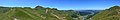
 Panoramic of Aix-les-Bains from Belvedere du Revard
 -
 Panoramic of Le Bonhomme, dept. Haut-Rhin
 -
 Route du Vin, Mittelwihr, dept. Haut-Rhin
 -
 Place de la Réunion, Mulhouse, dept. Haut-Rhin
 -
 Building of the Prefecture, dept. Territoire de Belfort
 -
 Place Joffre, Thann, dept. Haut-Rhin
 -
 Vineyards near Kaysersberg, dept. Haut-Rhin
 -
 Parapenting on the Puy de Dôme, dept. Puy-de-Dôme
 -
 Place de la Sinne, Ribeauvillé, dept. Haut-Rhin
 -
 Public bookcase in Ribeauvillé, dept. Haut-Rhin
 -
 Jarsy, dept. Savoie
 -
 Le Bonhomme, dept. Haut-Rhin
 -
.jpg/120px-View_of_Le_Chatelard_(Savoie).jpg) Le Châtelard, dept.Savoie
Le Châtelard, dept.Savoie -
 Lescheraines, dept. Savoie
 -
 Town hall of Bézaudun-sur-Bîne, dept. Drôme
 -
 Town hall of Aspres-sur-Buëch, dept. Hautes-Alpes
 -
 Landscape near Autichamp, dept. Drôme
 -
 Col d'Alllos, dept. Alpes-de-Haute-Provence
 -
 On the GR5 hiking route near the Col des Fourches
 -
 On the GR5 hiking route near the Col du Vallonnet
 -
 On the GR5 hiking route north of the Pas de la Cavale
 -
 Sign at the start/end of hiking route GR6 in Fouillouse, dept. Alpes-de-Haute-Provence
 -
 On the GR9 hiking route between Grand Montrond en Petit Montrond
 -
 View from hiking route GR94 on Veynes, dept. Hautes-Alpes
 -
 View from hiking route GR94 Serres, dept. Hautes-Alpes
 -
 Centre of Jausiers, dept. Alpes-de-Haute-Provence
 -
 Town hall of La Roche-sur-Grane, dept. Drôme
 -
 View from the church of La Roche-sur-Grane, dept. Drôme
 -
 Town hall of Montmaur, dept. Hautes-Alpes
 -
 Town hall of Bollezeele, dept. Nord
 -
 Town hall of Socx, dept. Nord
 -
_post_office.jpg/120px-Watten_(Nord)_post_office.jpg) Post office of Watten, dept. Nord
Post office of Watten, dept. Nord -
 Town hall of Bréal-sous-Montfort, dept. Ille-et-Vilaine
 -
 Town hall of Châteaubourg, dept. Ille-et-Vilaine
 -
 Centre of Plessix-Balisson, mun. Beaussais-sur-Mer, dept. Côtes-d'Armor
 -
 Sign indicating location of emergency telephones on hiking route GR34/E9 at Saint-Cast-le-Guido, dept. Côtes-d'Armor
 -
 Town hall of Tréfumel, dept. Côtes-d'Armor
 -
 Public wash houses in Pontrieux, dept. Côtes-d'Armor
 -
 On hiking route GR34/E9 north of Plougrescant, dept. Côtes-d'Armor
 -
 Town hall and war monument of Quemper-Guézennec, dept. Côtes-d'Armor
 -
 Map of hiking route Voie de l'Abbaye de Beaufort at the km 0 point at the Abbey, dept. Côtes-d'Armor
 -
 Km 0 sign of hiking route Voie de l'Abbaye de Beaufort
 -
 On hiking route GR34/E9 near Pointe de Bilfot, dept. Côtes-d'Armor
 -
 Hiking routes GR37, E5 and Voie de l'Abbaye de Beaufort in Josselin, dept. Morbihan
 -
 On hiking route GR34 north of Saint-Gildas-de-Rhuys, dept. Morbihan
 -
 Bassin du Commerce, Dunkirk, dept. Nord
 -
 Library of Montfort-sur-Meu, dept. Ille-et-Vilaine
 -
 Meuse at Montigny-sur-Meuse, dept. Ardennes
 -
 Town hall of Montigny-sur-Meuse, dept. Ardennes
 -
 Meuse at Revin, dept. Ardennes
 -
 Vireux-Molhain and Meuse, dept. Ardennes
 -
 Town hall of Vireux-Molhain, dept. Ardennes
 -
 Eglise Saint-Vinebaud and war monument, Humes-Jorquenay, dept. Haut-Marne
 -
 View from hiking route GR6 at La Caume, just south of Saint-Remy-de-Provence, dept. Bouches-du-Rhône
 -
 Library in Cadenet, dept. Vaucluse
 -
 Place de la Croix, Oppède-le-Vieux, dept. Vaucluse
 -
 GR6 hiking route near the Abbaye de Senanque, Gordes, dept. Vaucluse
 -
 Esplanade le Cours, Vinon-sur-Verdon, dept. Var
 -
 Request stop sign at Allons-Argens station, dept. Alpes-de-Haute-Provence
 -
 AMP 800 class DMU of Chemins de fer de Provence passing Allons-Argens station
 -
 Center of Allons, dept. Alpes-de-Haute-Provence
 -
 View of Thorame-Haute, dept. Alpes-de-Haute-Provence
 -
.jpg/120px-Le_Moustier_(commune_de_Thorame-Basse).jpg) Hamlet of Le Moustier, municipality of Thorame-Basse, dept. Alpes-de-Haute-Provence
Hamlet of Le Moustier, municipality of Thorame-Basse, dept. Alpes-de-Haute-Provence -
 Église Saint-Pierre-ès-Liens, municipality of Thorame-Basse, dept. Alpes-de-Haute-Provence
 -
 War monument in Thorame-Basse, dept. Alpes-de-Haute-Provence
 -
 View of Thorame-Basse, dept. Alpes-de-Haute-Provence
 -
 Town hall of Thorame-Haute, dept. Alpes-de-Haute-Provence
 -
 Lac des Sagnes, Thorame-Haute, dept. Alpes-de-Haute-Provence
 -
 Statues above Lac de Castillon, Saint-André-les-Alpes, dept. Alpes-de-Haute-Provence
 -
_town_hall.jpg/120px-Angles_(Alpes_de_Haute-Provence)_town_hall.jpg) Town hall of Angles, dept. Alpes-de-Haute-Provence
Town hall of Angles, dept. Alpes-de-Haute-Provence -
 Place de la Fontaine, Luc-en-Diois, dept. Drôme
 -
 On hiking route GR93 arriving in Archiane, dept. Drôme
 -
 Public bookcase in Pont de Quart, Solaure en Diois, dept. Drôme
 -
 Rue de la Calade, Soyans, dept. Drôme
 -
 At the Pas de l'Essaure, depts. Drôme and Isère
 -
 Place de la Mairie, Saint-Jean-d'Herans, dept. Isère
 -
 Town hall of Saint-Jean-d'Hérans
 -
_church_St_Benoit.jpg/120px-Entraigues_(Isere)_church_St_Benoit.jpg) Church of St Benoit, Entraigues, dept. Isère
Church of St Benoit, Entraigues, dept. Isère -
_town_hall.jpg/80px-Entraigues_(Isere)_town_hall.jpg) Town hall of Entraigues
Town hall of Entraigues -
_Place_du_Docteur_Eyraud.jpg/120px-Entraigues_(Isere)_Place_du_Docteur_Eyraud.jpg) Entraigues, Place du Docteur Eyraud
Entraigues, Place du Docteur Eyraud -
_public_bookcase.jpg/120px-Entraigues_(Isere)_public_bookcase.jpg) Public bookcase in Entraigues
Public bookcase in Entraigues -
 Chapel in Valsenestre, Valjouffrey, dept. Isère
 -
 On hiking route GR54 north-west of Valsenestre
 -
 La Chapelle-en-Valjouffrey, town center with Eglise Notre Dame de l'Assomption
 -
 Saint-Michel-en-Beaumont, dept. Isère
 -
_church.jpg/80px-Sainte_Luce_(Isere)_church.jpg) Church of Sainte-Luce, dept. Isère
Church of Sainte-Luce, dept. Isère -
 Town hall of Châtel-Montagne, dept. Allier
 -
 Allier river at Vichy seen from hiking route GR463
 -
 Town hall of Arronnes, dept. Allier
 -
 Place de Johannisberg, Puligny-Montrachet, dept. Côte-d'Or
 -
 Town hall of Puligny-Montrachet
 -
 View of Chassagne-Montrachet, dept. Côte-d'Or
 -
 TGV Lyria in station Dijon-Ville
 -
 Veuvey-sur-Ouche and Canal de Bourgogne, dept. Côte-d'Or
 -
 Town hall of Veuvey-sur-Ouche
 -
 Cirque d'Archiane seen from hking route GR93, dept. Drôme
 -
 Lac de Saint-Pierre-Cognet seen from the hill of Le Chauvet, dept. Isère
 -
 Vineyards of Volnay, dept. Côte-d'Or
 -
 Vineyards of Meursault, dept. Côte-d'Or
 -
 Vineyards of Vosne-Romanée, dept. Côte-d'Or
 -
 View from the Col de Vars towards the east


_Mairie.jpg)


_town_hall.JPG)


_town_hall.JPG)


_town_hall.jpg)
_town_hall.jpg)
_town_hall.jpg)
_center.jpg)
_town_hall.jpg)
_town_hall.jpg)

_former_railway_station.jpg)
_town_hall.jpg)
.jpg)
.jpg)
.jpg)
.jpg)


_tourist_office.jpg)


_town_hall.jpg)


.jpg)


_post_office.jpg)


.jpg)


_town_hall.jpg)


_church_St_Benoit.jpg)
_town_hall.jpg)
_Place_du_Docteur_Eyraud.jpg)
_public_bookcase.jpg)


_church.jpg)


Other countries
[edit]-
 Leipzig Hauptbahnhof shopping arcade
 -
 Chapel on the pass between Saint-Jean-Pied-de-Port, France, and Roncesvalles, Spain, on the Way of Saint James
 -
 Pilgrims on the Way of Saint James east of Castrojeriz, provinde of Burgos, Spain
 -
 Refugio on the Way of Saint James near Itero de Castillo, province of Burgos, Spain
 -
 Reconstruction of Mies van der Rohe's pavillion, Barcelona
 -
 Interior of Alstom X60 EMU, operated by SL, Sweden
 -
 View from Grinda island, Sweden
 -
 View on the harbour of Grinda island, Sweden
 -
 Booking hall of Ghent-Sint-Pieters train station
 -
 High Atlas between Marrakech and Tizi n'Test pass
 -
_Plaza_del_Toril.jpg/80px-Coin_(Malaga)_Plaza_del_Toril.jpg) Coín, Plaza del Toril (Spain)
Coín, Plaza del Toril (Spain) -
_Calle_de_la_Calzada.jpg/80px-El_Burgo_(Malaga)_Calle_de_la_Calzada.jpg) El Burgo, Calla de la Calzada (Spain)
El Burgo, Calla de la Calzada (Spain) -
_Calle_Nueva.jpg/80px-Yunquera_(Malaga)_Calle_Nueva.jpg) Yunquera, Calle Nueva (Spain)
Yunquera, Calle Nueva (Spain) -
 In the Sierra de los Nieves near Penon de los Enamorados (Spain)
 -
 In the Sierra de los Nieves near Penon de Ronda (Spain)
 -
 In the Sierra de las Nieves near Tolox (Spain)
 -
 Abandoned building site in Canovelles, Catalonia
 -
 On the Rheinsteig: Wellmich and Burg Maus
 -
 On the Rheinsteig, south of the Loreley
 -
 On the Rheinsteig: Kaub and Die Pfalz
 -
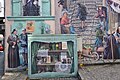
 Mural in Los Llanos, La Palma, Canary Islands
 -
 GR-131 hiking route start/end: Faro de Funacliente, La Palma, Canary Islands
 -
 GR-131 hiking route near Roque de los Muchachos, La Palma, Canary Islands
 -
 GR-131 hiking route near Santo Domingo de Garafia, La Palma, Canary Islands
 -
 Decorations in the train shed of Rossio station, Lisbon
 -
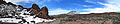 GR-131 hiking route in Teide national park, Tenerife, Canary Islands
 -
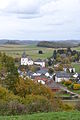 View of Steffeln, Eifel, Germany
 -
 Praça de Republica, Cabeceiros de Basto, Portugal
 -
 Largo do Toural, Guimarães, Portugal
 -
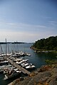
 Harbour of Pasaia, Basque Country, Spain
 -
 View of Castelo de Vide, Portugal
 -
 On the Moselsteig hiking route at Mont Royal, north of Traben-Trarbach, Germany
 -
 On the Moselsteig hiking route just north of Traben-Trarbach, Germany
 -
 Starting point of European hiking route E9 at Cape St. Vincent, Portugal
 -
 Sketch map of the route of the Rheinsteig hiking route
 -
 Sketch map of the route of the Moselsteig hiking route
 -
 Sketch map of the route of the Thames Path
 -
 Landscape near Marvão, Portugal
 -
 The Rhine in Basel, seen from the Münster terrace
 -
 The Rhine in Basel, seen from the Wettsteinbrücke
 -
 Landscape near Riezlern, Kleinwalsertal, Austria
 -
 Oberstdorf, Bayern, Germany
 -
 Sonthofen, Bayern, Germany
 -
 View of Zell, Germany, from the Moselsteig hiking route
 -
 View of Merl (near Zell), Germany, from the Moselsteig hiking route
 -
 On the GR5 hiking route: on the bridge of Schengen, Luxemburg
 -
 Moselle at Ehnen, Luxemburg
 -
 View of Ahn, Luxemburg
 -
 Colle della Maddalena, Italy (actually, the pass is on the French-Italian border but this photo was taken in Italy)


_Plaza_del_Toril.jpg)
_Calle_de_la_Calzada.jpg)
_Calle_Nueva.jpg)


History
[edit]-
 Approximate course of German and British naval vessels during the pursuit of German vessels Goeben and Breslau, August 1914

Geography
[edit]-
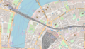 Location of London Waterloo Station and London Waterloo East Station, actually just a cutout from Open Street Map, added Open Street Map-template

Economics and financial markets
[edit]-
 Graph of monthly trade balance figures of the US
 -
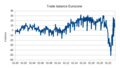 Graph of monthly trade balance figures of the Eurozone
 -
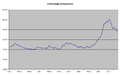
 U.S. house prices development based on FHFA (formerly OFHEO) data
 -
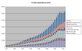
 Pension capital in a number of European countries
 -
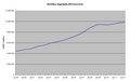
 House prices in the Netherlands
 -
 Main rates of Federal Reserve, ECB and Bank of England
 -
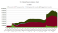 US Federal Reserve balance sheet total
 -
 Eurosystem balance sheet total
 -
 The three types of yieldcurve (not on any particular dates, just as an example)
 -
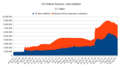
 US debt outstanding by sector
 -
 Houses for sale in the Netherlands
 -
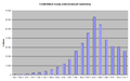
 Price increases of a number of Dutch consumer goods and services, 1999-2009
 -
 Development of coverage ratio of Dutch pension funds
 -
 Unemployment rate Eurozone
 -
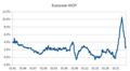 Harmonized Index of Consumer Prices Eurozone
 -
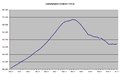
 GDP Eurozone
 -
 Total debt in the Eurozone
 -
 US mortgage delinquencies
 -
 Goverment debt in a number of European countries, plus Eurozone, plus EU
 -
 Government debt in the Eurozone, quarterly figures
 -
 Oustanding volume (notional amount) of credit default swaps
 -
 Monetary Aggregate (M3) of the Eurozone
 -
 Condensed balance sheet of the Federal Reserve, liabilities
 -
 Types of pension schemes in the Netherlands
 -
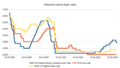
 Yields of selected long-term Eurozone government bonds
 -
 Irish house prices from 2005 (source: Irish CSO)
 -
 Misery index of selected countries, end of 2010
 -
 Misery index of Greece from 2008
 -
 US GDP from 2007
 -
 Unemployment rate of the US (U3) from 1970
 -
 Average duration of unemployment in the US
 -
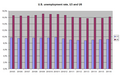 Relationship between U3 and U6 definitions of US unemployment
 -
 Development of participants in US Supplementary Nutritional Assistance Program
 -
 Development of US personal savings rate
 -
 Change of employment during 5 different recessions in the US
 -
 Development of financial obligations of US households
 -
 US international investment position
 -
 Yields on 1-month, 10-year and 30-year US government debt
 -
 US government debt ceiling from 1990
 -
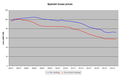 Spanish house prices from 2007
 -
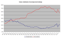 Greece: distribution of sovereign bonds holdings
 -
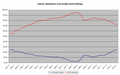 Ireland: distribution of sovereign bond holdings
 -
 Italy: distribution of sovereign bond holdings
 -
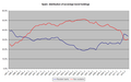 Spain:distribution of sovereign bond holdings
 -
 France:distribution of sovereign bond holdings
 -
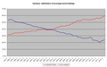 Germany: distribution of sovereign bond holdings
 -
 Netherlands: distribution of sovereign bond holdings
 -
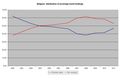 Belgium: distribution of sovereign bond holdings
 -
 Finland: distribution of sovereign bond holdings
 -
 Pension fund assets as percentage of GDP, 2011
 -
 Monthly unemployment rates in the EU, Eurozone and a number of Eurozone countries
 -
 Dutch house prices indices (source: Dutch central statistics office)
 -
 Demo of municipal council workers, Lisbon, Portugal, 15 March 2013
 -
 Bank of Japan balance sheet total
 -
 US federal government debt ceiling from 1990 to October 2013
 -
 Use of ECB deposit facility
 -
.png/120px-Use_of_ECB_deposit_facility_(in_Libre_Office).png) Basically the same graph, but made using LibreOffice
Basically the same graph, but made using LibreOffice -
.png/120px-Eurosystem_balance_sheet_total_(in_LibreOffice).png) Development of ECB balance sheet, basically the same graph as above (but updated), but made using LibreOffice
Development of ECB balance sheet, basically the same graph as above (but updated), but made using LibreOffice -
 Dutch house prices since 2000, graph now made using LibreOffice
 -
 ECB and Federal Reserve main policy rates from January 2022
 -
 Government debt of a number of Euopean countries since 2012


.png)
.png)


Uploads not of my making
[edit]-
 Laantje van Van der Gaag, 1847, near Delft
 -
 Unsold apartments in Saggart, Ireland
 -
 Demo in Athens, June 2011
 -
 Closed shops in Ibiza, July 2012
 -
 Abandoned construction project, Cyprus, may 2013


nl | Deze gebruiker heeft het Nederlands als moedertaal. |
en-2 | This user is able to contribute with an intermediate level of English. |